Keswick Adventures Blog
News and information about our activities and the local area


Walking in and around Keswick is a real pleasure thanks to the beautiful scenery, range of options, and easy access. It can be just a few minutes by foot, car, boat or bus until you're at the base of a mountain or along the side of a lake.
We've spent many years walking around Keswick, so we're confident we can share the best walks with you! Try these routes out or, if you want the additional support on a particularly challenging hike, we can offer guided walks. Just get in touch.
Or if you want something to do in between walking days, book one of our outdoor activities.
For gentle evening strolls, a potter with all the family, and flat accessible routes, these options are just the ticket. Take a look at these, or browse our full guide to the best easy walks in Keswick.
Approximate distance: 2 - 5km / 1 - 3 miles
You can begin the walk up Latrigg from Keswick itself, or from the car park close to the top of this small fell. Both options are easy, though the one from town requires more of a (gentle) uphill climb. From the car park, it's a fairly flat route to the summit.
Whichever option you go for, you'll get amazing views over Keswick, Derwentwater and Bassenthwaite Lake and will be able to admire the surrounding higher fells such as Skiddaw and Blencathra.
Approximate distance: Variable, up to 10km / 6 miles
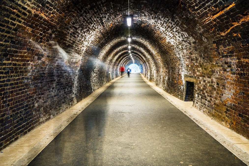
Though there's no train station in Keswick nowadays, there used to be a busy line stretch from the west coast to the eastern edges of the Lake District. Now, the Keswick section of that line is a pleasant flat walk that's accessible to both wheelchairs and prams.
The route is fully paved and almost entirely flat all the way to its end at the village of Threlkeld. It twists through pretty woodland, alongside winding rivers, and even through old railway tunnels. Information boards along the way provide further information to its history.
If you want to do the whole 5km route to Threlkeld without retracing your footsteps to the start again, buses run close by each end. Or you can just walk as far as you fancy and then turn back. Additional paths run in different directions through the woods and up Latrigg, though be aware that these are no suitable for wheelchairs and buggies.
Approximate distance: 2.5km / 1.5 miles
Potter down to the lake from the centre of Keswick and then head left along the shore along a flat, clearly marked path. This will take you to Friar's Crag, a wonderful viewpoint that overlooks Derwentwater and the craggy mountains of Borrowdale beyond. The shady walk passes through a small woodland, and eventually opens out onto Strandshag Bay. Look out for Lord's Island across the water, which was once home to a grand manor house and is now a bird reserve.
The walk up to Friar's Crag is a Miles Without Stiles route so is accessible for prams and wheelchairs. Access from here to Strandshag Bay is via a kissing gate and onto a pebbled beach. The route back is via the way you came.
If you're up for something a little more challenging - but not too much! - then these are the routes for you. These Keswick walks take you up some of the smaller fells or are longer walks along easy paths.
Approximate distance: 6km / 3.5 miles
One of Keswick's most iconic mountains, Catbells peers over at the town from the far side of Derwentwater. You can walk, drive, sail, or catch a bus to the starting point (or close by), which is a car park at the foot of the fell.
The double hump of Catbells is great fun to climb. There's some optional scrambling at the top that kids will especially enjoy, and you get to the top feeling proud of your effort, without feeling exhausted! The way back down is via a circular route which drops to the lake-side of the mountain and follows a clear path on the lower slopes.
Approximate distance: 16km / 10 miles
Though this circular walk around the whole of Derwentwater isn't particularly difficult, it is quite long, so will be something of a challenge if you're not used to longer hikes. However, it's a varied and interesting route with lots of great scenery to see. There are some options for small detours, including to Lodore Falls, a couple of pubs for a refreshment break, and up to Surprise View and Ashness Bridge. If you don't want to stop at a pub, don't forget to bring a picnic!
The route is waymarked throughout, with decent paths. A number of car parks around the lake mean that you can pick your starting point, but if you're staying in Keswick, then you can walk to the shore directly from town and start from there.
If you find part-way through that the walk is too long, the Keswick Launch stops at a number of jetties around the lake and can take you back to town.
Approximate distance: 6.5km / 4 miles
Just a short drive from Keswick is the beautiful valley of Borrowdale. Castle Crag is one of the smaller fells in the region and this walk takes in hermit caves, riverside paths, and views of Derwentwater. Starting in the village of Rosthwaite, you follow the path along to the hermit caves, where "Professor of Adventure" Millican Dalton lived for nearly 50 summers!
The route shortly continues uphill to the shoulder of the mountain, at which point you can start ascending a steep and zig-zaggy path towards the true summit. Up here, look out for a memorial stone commemorating local men who died in WWI.
If you don't fancy the climb right to the top, it's also possible to skip the final summit and just continue over the shoulder. If you have gone to the top, retrace your steps down to the shoulder and continue on your way. You'll eventually complete the circle back to Rosthwaite.
Approximate distance: 10.5km / 6.5 miles
Another walk from the centre of Keswick, this moderate hike ends up at picturesque Ashness Bridge before looping back to your starting point via the lake.
From the centre of town, head east into a residential area of Keswick and up towards Castlerigg Campsite via Springs Wood. It's not long before you're on the open fell and much of the way involves following a stone wall along the top of the crag. There's an optional mini diversion that takes you closer along the cliff edge (with great views), but take great care if you choose to follow this path.
Ensure you keep to the lower slopes, otherwise you could end up at the top of High Street, a much higher fell! You'll eventually reach a minor road and the famous Ashness Bridge before following the road downhill where you'll join a path that follows Derwentwater's shore closely until you return to Keswick.
Approximate distance: 10km / 6 miles
As the fourth highest mountain in the Lake District, you would think that Skiddaw would be a difficult climb. In fact, it's a fairly straightforward hike (albeit a long way to go up!) and, as one of the national park's most iconic mountains, one to tick off your bucket list!
Despite easy-to-follow paths and a gradual climb, Skiddaw is still a tall mountain at over 3,000 feet, so you do need to take appropriate care. But the path is clear and the top wide and flat for much of the way, so there's not too much risk of you plummeting off a cliff.
You can start at the same car park as you do for the Latrigg walk, which is already part way up the mountain. Then it's just a matter of following the path up Jenkin Hill and Little Man all the way to the top. Be aware of false summits, which will make you think you've arrived at the peak before you have! But at the top - because of it's position high above all the other fells in the area - you'll have unbeatable 360-degree views!
When you're done, simply head back down the way you came.
If you're an experienced hiker and would like a walk that offers more of a challenge, see what you think of these hikes. Remember to make sure you're fully prepared and have all the necessary equipment and navigation skills. Keep an eye on the weather, too, which can change dramatically between the valley bottom and the fell tops.
If you're keen to do a hard hike but aren't sure you have the right experience, remember that we can offer guided walks and will be able to advise on something suitably challenging for your abilities. Just get in touch to find out more.
Approximate distance: 13km / 8 miles
The more famous Striding Edge on Helvellyn is the ridge that most walkers want to experience. But Sharp Edge is much closer to Derwentwater and is arguably more challenging. You can see it from the main road coming into Keswick from Penrith, and it looks almost vertical! It's not quite that steep when you get up there, but does involve scrambling and is very narrow.
If you get to the bottom of the ridge and decide it's not for you - and there's no shame in that! - there's an alternative and more gentle route on the opposite side of Scales Tarn. So you can still reach the top without the scramble if you prefer. As one of the tallest mountains in the Lake District, Blencathra is a challenging walk with or without Sharp Edge!
Approximate distance: 16km / 10 miles
If one mountain at a time simply isn't enough for you, then you'll love the Newlands Horseshoe, which covers 6 fells: Robinson, Hindscarth, Dale Head, Catbells, Maiden Moor and High Spy. An epic day out! Throughout, you'll have wonderful views of the Newlands Valley (where we hold most of our ghyll scrambling activities), Derwentwater, Buttermere and Borrowdale. In fact, this walk gives you a bird's eye view of most of the North West Lake District!
There are a couple of small car parks around the hamlet of Little Town. As this is a full-day walk, you'll want to arrive early so hopefully won't have too much trouble finding a space. Starting at the Robinson end of the walk is probably the best option, as it saves you a tedious uphill trudge on the other side of Dale Head.
The route itself is reasonably easy to follow (though remember to take your map and compass!), which the most technical part of the walk coming on the descent from catbells towards the end, which is rocky and may require some very minor scrambling. But overall, it's the length and 'up-and-down' of this route that makes it a more challenging walk. In exchange for the incredible views, though, we think it's well worth it!
Of course, this is just a small selection of the many walks around Keswick. Even living here, we manage to find different routes and new walks all the time. The town and surrounding countryside is excellent to explore by foot, and we hope these hikes form a memorable part of your holiday!
Still got some energy left after your walk? Then book one of our adventure activities.
![]()
Crosthwaite Rd, Keswick, CA12 5PP
info@keswickadventures.co.uk
07712 162088
Licensed by the Adventure Activities Licensing Scheme (AALS).
